Why does GPX route info vary on different platforms?
Matty Abel • 2023-04-21
We dig into why when you load a GPX file into various platforms, the resulting distances and elevation gain totals can differ significantly.

If you’re a trail runner who uses different mapping platforms, such as Avenza, Plotaroute, Garmin Connect, Strava, or AllTrails to track your runs, you may have noticed that when you load a GPX file into these platforms, the resulting distances and elevation gain totals can differ significantly.
These variances can be frustrating, especially if you're trying to gauge what your upcoming race metrics really are. In this blog post, we'll explore why GPX file variances occur and what you can do about them.
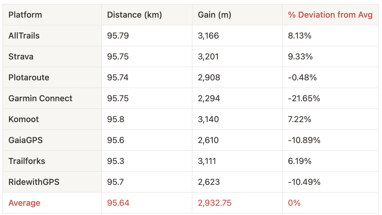
Let’s use this sample GPX file from a US race. Distance is pretty consistent in this case but estimated elevation gain varies widely.
GPX file variances can occur for a number of reasons:
- Different platforms use different algorithms to calculate distance and elevation gain. These algorithms take into account a range of factors, such as terrain, GPS accuracy, and altitude data. Therefore, even if the GPX file contains the same GPS data, the resulting distances and elevation gain totals can differ depending on the platform's algorithm. Here’s a great article from Strava on how they tackle the challenge of working out elevation details, as you can see it’s a complicated effort!
- Different mapping platforms may use different base maps or elevation data sources, which can result in differences in the measured elevation gain.
- Some platforms apply smoothing algorithms to the GPS data in order to eliminate noise and make the resulting route or elevation profile look smoother. While this can result in a more aesthetically pleasing output, it can also affect the measured distance and elevation gain.
- GPS accuracy can vary depending on the device used to record the data, the environment in which the data was recorded, and other factors. Some platforms apply corrections or filtering to the GPS data to improve accuracy, which can also affect the measured distance and elevation gain.
- User error can also play a role in GPX file variances. For example, selecting the wrong activity type or not adjusting settings correctly can affect the measured distance and elevation gain.
So, what can you do about GPX file variances? Firstly, it's important to remember that GPS data is not always perfectly accurate, especially when it comes to off road events, and that different platforms may use different methods to calculate distance and elevation gain. Therefore, it's generally a good idea to compare results across multiple platforms to get a more accurate picture of your activity of choice.
In conclusion, GPX file variances are a common issue for trail runners and off-road enthusiasts across different mapping platforms. While frustrating, these variances will not diminish your overall accomplishment and experience out in the wild.